


 Visão geral do jogo
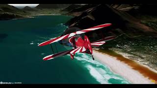
GeoFS is a flight simulator with scenery built from satellite images.
This free "light" version includes 3 fully functional aircraft and a flyable area covering the french island of Corsica (20000 km² | 8000 square miles). All the data is included in the app so no internet connection in necessary: fly offline!
This app includes:
- Corsica at 10m resolution satellite images
- Realistic physics and flight models
- Navigation map with referenced runways and airspace visualization
- 3 aircraft with instrumented cockpits
- Replay mode
- Configurable weather conditions (wind, clouds, fog, precipitations)
- Night time with runway lights
Included aircraft:
- Cessna 172
- Alphajet PAF
- Boeing 737-700
For the full version including multiplayer, 11 different aircraft, global flyable area and HD images on purchase, please download the GeoFS app at https://play.google.com/store/apps/details?id=com.geofs.sd

 Fale do jogo
no nosso Discord


Desenvolvedor
Mais jogos de GeoFS